
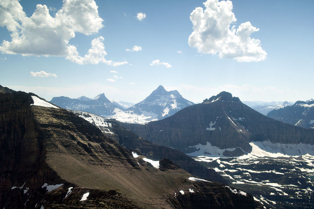
Located in Northwestern Montana, Glacier National Park stretches over 1 million acres (4,000 square km) and includes two sub-ranges of the Rocky Mountains, more than 130 lakes, over 1000 unique species of plants, and several different species of animals. The park is nicknamed Crown of the Continent and is a very popular spot for mountaineers enabling them to explore pristine wilderness and vast array of the crag.
Over 170 million years ago, the mountains in Glacier National Park began to form. They formed when the ancient rocks forced their way over younger rock strata. This process was named Lewis Overthrust. The present symmetry of the mountain ranges (Lewis & Clark and Livingston) and the size and position of the lakes are a result of enormous glacial action.
The mountains found in Glacier National Park are part of the Rocky Mountains. The park is home to more than 150 mountain peaks that measure over 8,000 ft (2,438 m) situated in two mountain ranges, namely: Livingston Range and Lewis & Clark Range. Only a tiny portion of the Lewis & Clark Range is located in northwestern Montana with the majority in the Canadian provinces of Alberta and British Columbia. Overall, the highest mountain peak in the park is Mount Cleveland.
MOUNT CLEVELAND
Measured at 10,466 ft (3190 m) tall, Mount Cleveland is the highest mountain located in the Glacier National Park, also the highest mountain in the Lewis & Clark Range. It is located 5 miles (8 km) to the south of the US-Canada border, and 3 miles (4.8 km) southeast of Waterton Lake.
If you plot a temperature graph of Mount Cleveland throughout the year for 12 months, we will get a parabolic curve. The lowest temperature is -2 degrees F (-19 degrees C) in January, while the highest temperature is recorded at 48 degrees F (9 degrees C) in July.

The best time to summit Mount Cleveland is mid-July to August. Attempts to climb the mountain in June are difficult due to snow on the narrow ledges (Stoney Indian peaks), while attempts to scale the peak in September is not recommended either because the summit pyramid is blanketed by ice and snow.
There are three main routes by which we can ascend or descend Mount Cleveland:
- West Face Route: The least difficult route on the mountain is the West Face Route which starts from Waterton Valley. It was first climbed in 1920 by Frank B. Wynn. In total is it about 8 miles (12 km), out of which on 2 (3.2 km) are by human trial.
- Stoney Indian Route: In 1937, this route was descended by a member of SIERRA CLUB, who scaled the mountain using West Face Route, but were searching for a shortened journey to their campsite at Stoney Indian Lake.
- Southeast Face Route: In 1983, the Kennedy brothers climbed this route. It includes a 10-mile (16 km) hike from Chief Mountain Customs Station to Glenns Lake.
The wildlife present on the summit of Mount Cleveland includes grizzly bears who regularly climb to the top of the mountain to feed on moths who have inhabited the area for a long time.
MOUNT STIMSON
Being the second highest peak in Glacier National Park, Mount Stimson is 10,147 ft. (3,093 m) tall. Like Mount Cleveland, it is also part of the Lewis & Clark Range that stretches across most of the park. It is located around 5 miles (8km) to the west of the Continental Divide, and 12 miles (19km) southeast of McDonald Lake which is a remote southwestern part of the park.
The temperature curve of Mt. Stimson is similar to that of Mt. Cleveland with July being the hottest month – 50 degrees F (10 degrees C) and January and December being the coldest months – 14 degrees F (10 degrees C).
Since the location of Mount Stimson is in one of the remote corners of the park arriving at the base of this peak is no easy task. The Nyack Valley is sparsely inhabited; therefore the trails in this location are not managed properly. The path is sometimes blocked by downed trees as a result of storms, and the local management takes time to clear them.
The three main routes of Mt. Stimson are:
- Southeast Ridge Route: It begins at Beaver Woman Lake, 24.8 miles (40 km) up the Nyack Creek trail. The trail begins along Highway 2 which is near Walton Ranger Station.
- Two Medicine Lake Route: This is a more picturesque route that starts on the eastern side of the park. The challenging aspect of this route is climbing 3000 feet (914 m) over the continental divide, however, the plus point of this ascent is that we get to see stunning and majestic scenery the remote area of the park has to offer.
- West Ridge Route: It requires a 12-mile (19 km) hike from Nyack Valley.
The wildlife that can be encountered on Mt. Stimson includes huge elks, golden eagles, wolverines, wolves, and cats.
KINTLA PEAK
Being part of the Livingston Range in Glacier National Park, as well as the highest peak in the range, and the third tallest mountain in the park, Kintla Peak measured 10,106 ft. (3,080m), it lies in the remote northwest corner of the park. The Aggasiz Glacier lies below this peak to the southeast.
Its temperature is almost identical to that of Mt. Stimson all year round. Depending on the amount of snow the best months to climb are July, August, September, and October.

This site is inaccessible to most people, except for the intrepid mountaineers willing to take enough equipment and goods with them to survive one or two nights in the high country.
The Standard Route to the peak is the Southeast Ridge Route, which starts from the Aggasiz Glacier basin. The route involves a tedious approach, large vertical gain, and Class 4 rock scrambling. This is in addition to climbing on snow (depending on which season it is). Other routes include the Upper North face route, West face, and East Ridge route.
Grizzly bears are the most common wildlife found in this remote area.
Apart from the 3 tallest mountains mentioned above, there are 150 plus mountains in the Glacier National Park, most of which are in the Livingston and Lewis & Clark mountain ranges. Each mountain has its unique climate, wildlife, and routes with stunning views and breathtaking wilderness.